Using the Puget Sound Watershed Characterization to Inform Decisions
By using the Puget Sound Watershed Characterization data and results, planners and decision- makers can:
The Characterization information can help answer two fundamental questions:
As part of the “watershed framework” approach, the following five-steps can used to facilitate a watershed-based decision. The steps are:
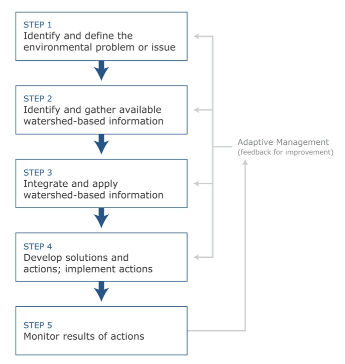
See the User Guide for more information on the watershed framework.
Limitations
Care should be taken to use the Puget Sound Watershed Characterization as intended. It is a coarse-scale assessment and is not intended for site scale decisions; finer scale data will be needed for these decisions. Even at larger scales, finer scale and local information to supplement the watershed-level characterization will improve decision-making. There are other limitations that be taken into account when using this data:
By using the Puget Sound Watershed Characterization data and results, planners and decision- makers can:
- Develop and prioritize solutions to environmental problems based on an understanding of processes at a watershed or landscape scale;
- Replace planning based solely on jurisdictional boundaries with broader-scale more coordinated regional planning;
- Guide site-scale reviews with watershed-scale context on ecological processes to ensure projects not only meet regulatory requirements but also more fully achieve their intended outcomes;
- Move towards integrated resource planning and management grounded in a landscape- scale understanding of how ecosystems work.
The Characterization information can help answer two fundamental questions:
- 1. where on the landscape should management efforts be focused first, be they actions for planning (e.g., protection) or mitigation (e.g., restoration); and
- 2. what types of activities and actions are most appropriate to that place, be they restoration, protection, conservation, or development?
As part of the “watershed framework” approach, the following five-steps can used to facilitate a watershed-based decision. The steps are:
See the User Guide for more information on the watershed framework.
Limitations
Care should be taken to use the Puget Sound Watershed Characterization as intended. It is a coarse-scale assessment and is not intended for site scale decisions; finer scale data will be needed for these decisions. Even at larger scales, finer scale and local information to supplement the watershed-level characterization will improve decision-making. There are other limitations that be taken into account when using this data:
- The Puget Sound Watershed Characterization is for planning purposes only. This information does not affect or alter existing land use/environmental regulations although it can be used to help inform future land use and regulatory decisions.
- The water quality assessments that are part of the Characterization are different from the State’s Clean Water Act-mandated water quality assessment. The water quality ratings for each Assessment Unit (AU) are separate from and have no bearing on 303-d listings or any other aspect of the assessments required under Sections 303(d) and 305(b) of the federal Clean Water Act.
- In the main website display, results for water flow and water quality assessments are presented within landscape groups in each Water Resources Inventory Area (WRIA. This means it’s not appropriate to compare the AUs ratings in one WRIA to AU ratings in a different WRIA. A Puget Sound Basin-wide scale that would allow such comparisons is available for download from Ecology. The terrestrial habitat assessment results are presented at the Puget Sound scale, so cross-WRIA comparisons are appropriate. The freshwater fish assessment results are presented at the WRIA scale, and the marine shoreline results are presented by oceanographic sub-basin so those results are comparable only within WRIA and sub-basins, respectively.
- Users should always examine the overall integrity of a Watershed Management Unit (WMU) relative to the actions within a single AU. Each AU will represent a combination of on-the-ground challenges and opportunities. Just because an AU is rated as a low priority for restoration does not mean there are no suitable restoration sites / opportunities in the AU. Similarly, not every site in an AU that is a high priority for restoration will be suitable for restoration. See How to Get Started or the User Guide for more information.
- The indices of relative conservation value are not comprehensive. They do not explicitly include all species, do not fully address habitat connectivity and do not address species or habitats that are mostly confined to higher elevations (>2000 ft) on public lands. The assessments may not adequately address the particular habitat needs of rare or imperiled (i.e., state or federally listed) species or species highly susceptible to human disturbance.
- The models developed for each of the assessments were based on a number of subjective judgments for which there was uncertainty: which factors to include, their relative influence, and how to assemble them. Through numerous meetings with experts and intensive peer review we believe we have developed useful, scientifically credible indices of relative value.